Today let’s continue our hike along the Grey Canal Trail visiting the Swan Lake east section. This trail runs high along the hills above the east side of Swan Lake, following the historic Grey Canal irrigation system that once provided precious water to the Vernon and Coldstream valleys. Many of the original canal structures are visible along this route showcasing the engineering marvels of our past. Admire breath-taking valley and lake views while strolling above orchards, farms, grazing horses and llamas.
The total trail length from Rugg Road to Glenhayes Road is 3.5 km, one-way. There are two separate sections of trail that can be hiked individually or all at once. No dogs allowed.
Rugg Road to McLennan Road: (1.3 km) The south end of the trail is on uneven dirt surface and the north end continues on the roadway (Grey Canal Road).
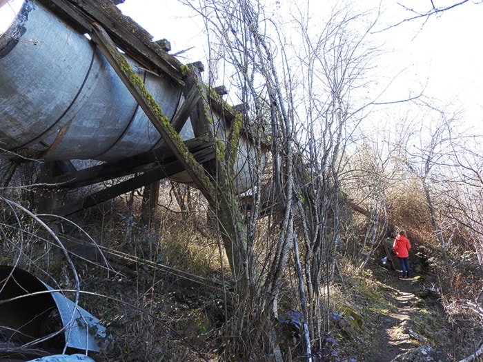
McLennan Road to Glenhayes Road: (2.2 km) You’ll encounter many remnants of the old canal structures including the longest flume along the Grey Canal, where water was carried in a suspended artificial channel above the rugged terrain. This challenging section has some of the most difficult and diverse terrain along the Grey Canal trail. Be cautious of rocky, uneven surfaces, descending gullies, and narrow trail portions. Interpretive signs explain the canal’s history and structures.
From L&A Road, three parking lots access the trail. Follow 48th Avenue east to Silver Star Road; turn left onto L&A:
- Rugg Road (south end of trail): On L&A continue straight (north) past Cools Road; turn right onto Rugg; turn right into the well-marked parking lot.
- McLennan Road (middle of trail): On L&A continue north past Rugg; turn right onto McLennan; parking lot is on the left at the Grey Canal Road intersection.
- Glenhayes Road (north end of trail): On L&A continue north; turn right onto Baker-Hogg Road; turn right onto Glenhayes; parking lot is on the left. Trailhead is 100m up Glenhayes on right.
Trailheads are marked with rectangular fenced gates.
The Grey Canal trail descends 830 meters further west from the Glenhayes parking lot down to Baker Hogg. Enter the trail through the metal horse gate at the south-west end of the Glenhayes parking lot. A trail map sign and metal horse gate are located at the trailhead on Baker Hogg.
Next month we’ll venture to the Coldstream Valley Estates section of the Grey Canal Trail. For downloadable trail maps and more trail information, visit the Ribbons of Green website (ribbonsofgreen.ca).
Happy trails!
Explore local trails is presented by the Ribbons of Green Trails Society, written by directors Ingrid Neumann and Claude Rioux.