Flood risk assessment and mitigation initiatives were embraced by the City of Vernon well before the flooding catastrophe that struck southern B.C. last November.
Mark Dowhaniuk, manager of infrastructure, said Vernon began forming a protection plan in response to flooding that occurred previously in 2017 and 2018 around Okanagan Lake, Kalamalka Lake, BX Creek and Vernon Creek.
“One of our main objectives is to put together detailed mapping to use for land management planning, emergency response planning and public awareness, as well as beginning to look at existing infrastructure upgrades that are needed,” Dowhaniuk said.
He said the study that helped define those objectives more clearly has resulted in seven main recommendations, starting with creation of a new flood control bylaw and Official Community Plan update now before council for final consideration.
Other goals will be to develop a flood emergency plan and flood hazard assessment (targeted for completion in 2022), structural mitigation predesigns (2022-23) and updated erosion and sediment flow control plan (2022-23).
Dowhaniuk was one one of the panel speakers at a virtual public forum hosted Wednesday (March 16) by the Okanagan Basin Water Board’s WaterWise program, an outreach and education initiative, in recognition of UN World Water Day, March 22.
He was asked to speak about the City of Vernon’s preparedness for climate change, both from a wildfire and flooding perspective.
Dowhaniuk said the city no longer questions communities being vulnerable to weather extreme conditions in the Okanagan, but how to minimize the impact on city and residential infrastructure.
“One of the things we really want to do is communicate this to the public, so we took a similar approach to what the water board has done with flood story mapping, to create a Vernon flood story map….where people can type in their address on a map and see how flooding could potentially impact their property,” he said.
The wildlife hazard area has previously been created by the city giving developers rules to follow in environmentally sensitive areas, but the White Rock wildfire devastation last summer has created a need to further enhance that plan.
“We are trying to promote to the public the need to adopt firesmart principles so we are moving forward in a couple of areas on that and the city has hired a full-time coordinator to help push those initiatives,” Dowhaniuk said.
Anna Warwick Sears, executive director of the Okanagan Basin Water Board and a panel participant, said Okanagan Valley communities face challenges posed by climate change in future land development, particularly in floodplain areas, often under pressure for waterfront residential housing growth.
“A lot of work has to be done locally on these issues. It takes a lot to make these changes and you don’t want to rush into it, but we can’t wait too much longer,” Warwick Sears said.
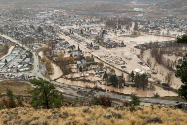
When considering the flood damage that occurred last November in nearby Merritt, she said “a sense of urgency” exists.
“This happened so close to us, these are our neighbours,” Warwick Sears said. “So climate change is very real and present when we see the affects right here in B.C. rather than in some other part of the world.”
She said Okanagan Lake level management remains the biggest long-term project affecting the entire Okanagan Valley watershed, which ultimately is going to result in an identified need for major infrastructure improvements to the existing lake level management system.
“Most of the existing structures were built in the 1950s so they are aging, and the operating plan model was created in the 1970s with the main objective then being flood control,” she said.
She said a study submitted to the provincial government last year outlined a series of impact studies required to devise a strategy and infrastructure upgrade plan to meet the climate change, fisheries and environment lake level needs, which often conflict between the north, central and south Okanagan ends of the watershed.
“That is what we need to do. We don’t want to reduce the drought risk by increasing the flood risk or harm fisheries restoration efforts,” she said.
READ MORE: Okanagan facing extreme flooding risk
READ MORE: Flood preparedness urged in Vernon
@VernonNews
newsroom@vernonmorningstar.com
Like us on Facebook and follow us on Twitter.