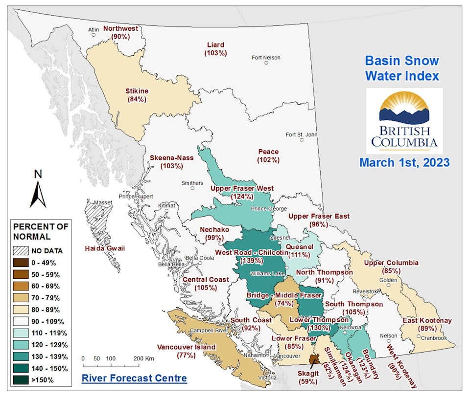
British Columbia’s March 1 snowpack is slightly below normal, but parts of the province have significantly more snow than usual.
The March 1 Snow Survey and Water Supply Bulletin, released by the BC River Forecast Centre, showed snow measurements averaged 94 per cent of normal across the province as of March 1. This is an increase from Feb. 1, when the average snow levels provincewide were at 79 per cent of normal levels.
READ ALSO: February snow measurements below normal for much of B.C.
READ ALSO: Summerland snow measurements above normal levels
The March 1 levels, show some regions of the province including the Boundary, Okanagan, Nicola and Upper Fraser West basins are all well above normal levels.
The March 1 measurements for the Upper Fraser West basin showed 124 per cent of normal levels. The Okanagan basin was also at 124 per cent of normal. The Boundary and Nicola basins were 123 per cent of normal. In addition, while the Middle Fraser region was below normal, some areas within this region had significantly more snow than usual.
Elsewhere in the province, the snow levels ranged from 59 per cent of normal in the Skagit region and 77 per cent of normal on Vancouver Island to 105 per cent of normal in the South Thompson and Central Coast regions.
A year earlier, the provincial snow levels were 105 per cent of normal.
According to the report, above-normal snow levels indicate a higher risk for snowmelt-related spring flooding in the affected areas. Areas with near-normal or below-normal levels may also experience flooding if adverse weather conditions occur.
By March 1, nearly 80 per cent of the snow pack has accumulated, but the total snow accumulation can still change significantly the report states.
In February, temperatures were near normal for much of the province. The month was drier than normal on Vancouver Island and on the South Coast, while Quesnel had the third wettest February since 1893.
While spring flooding conditions are difficult to predict, the report states that areas with an above-normal snowpack may have a higher risk of flooding in spring.
To report a typo, email:
news@summerlandreview.com.
news@summerlandreview.com
Like us on Facebook and follow us on Twitter.
